
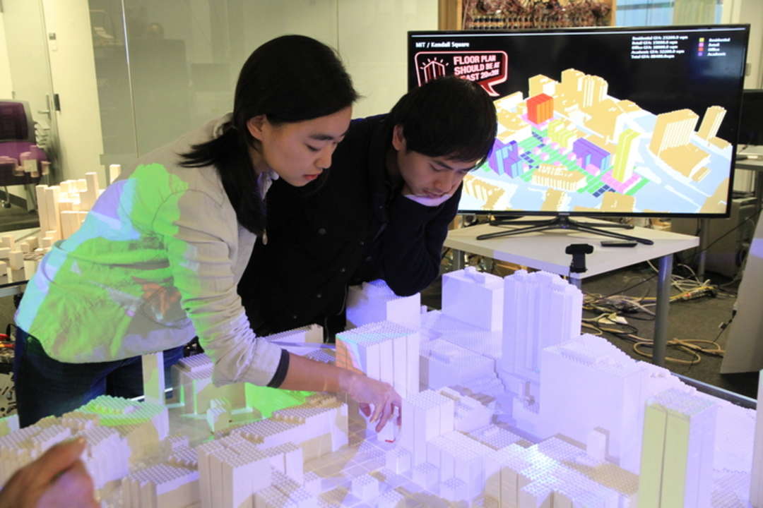
| CityScope Project is a powerful tool created by MIT's MediaLab that uses augmented reality to quickly and simply model the effects of large-scale urban-planning decisions, allowing urban planning to be more accessible to everyone. The technology employs TIM, a tangible-interactive rapid prototyping environment for matrices of data. TIM uses an array of optically tagged LEGO bricks on the tabletop with overhead projectors that beam color-coded metrics onto each brick: a combination of computer vision and 3D projection mapping. Overview from MIT's MediaLab: "We develop simulation systems to predict and quantify the potential impact of disruptive interventions within new and existing cities. We place a special emphasis on augmented reality decision support systems (ARDSS) that facilitate non-expert stakeholder collaboration within complex urban environments. Such systems blend hardware, software, human interface design, cloud computation, and variants of so-called big data. "CityScope" is an open source platform for shared, interactive computation." | El proyecto CityScope es una poderosa herramienta creada por el MediaLab del MIT (Massachusetts Institute of Technology) que utiliza la realidad aumentada para modelar los efectos de las decisiones urbanas a gran escala de una manera muy rápida y sencilla, permitiendo así que la planificación urbana sea más accesible. Se apoya en la tecnología TIM (Tangible-Interactive Mapping), un entorno de creación rápida de prototipados tangibles e interactivos a partir de matrices de datos. TIM se basa en un conjunto de piezas de LEGO con etiquetas ópticas, las cuales se colocan sobre la mesa-matriz; cada pieza recibe distintos haz de luz desde los proyectores suspendidos, siguiendo un código de colores. Se trata, por tanto, de una combinación de visión por ordenador y proyección 3D. Descripción del MIT MediaLab: "Desarrollamos sistemas de simulación para predecir y cuantificar el impacto potencial de las intervenciones más disruptivas en la ciudad, tanto nuevas como existentes. Ponemos especial énfasis en los sistemas de soporte de decisiones basados en realidad aumentada (ARDSS por sus siglas en inglés), que facilitan la colaboración entre las partes interesadas no expertas dentro de entornos urbanos complejos. Estos sistemas mezclan hardware, software, diseño de interfaz humana, cloud computing y una serie de variantes procedentes del Big-Data. "CityScope" es una plataforma abierta para la computación interactiva y compartida." |
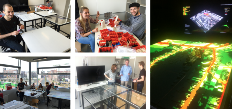
| This technology works at follows: every LEGO piece has a special chip that communicates with the overhead projectors, which beams metrics affected by each decision onto the new configuration. So, chips of each brick are assigned a user-determined variable such as “150-unit residential building,” “2-ha park” or “4-lane road”; and other variables such as walkability, access to jobs, housing or open space can easily be estimated in the following way: once assembled on the tabletop, the objects are able to represent an existing neighborhood, city or region, and users are able to pick up and insert, move or remove individual components while this changes to the city are visually revealed in real-time by changing color-codes projected onto the pieces. For example, if you placed a “150-unit residential building” piece onto a previously empty plot of land, the color of the street in front of the new building would change to indicate a quantifiable increase in traffic density. Thus, users from any background can configure the table collaboratively. | Esta tecnología funciona de la siguiente manera: cada pieza de LEGO dispone de un chip óptico que comunica con los proyectores suspendidos, los cuales parametrizan los datos recibidos y emiten distintos haz de luz según estos datos y, por tanto, cada decisión tomada afecta a cada nueva configuración. De esta manera, a los chips de cada pieza se les asigna una variable determinada por el usuario. Estas variables podrían ser tales como "Edificio de 150 unidades residenciales", "Parque de 2 hectáreas" o "Carretera de 4 carriles". Así, variables como transitabilidad peatonal, acceso a puestos de trabajo, densidad residencial o densidad de espacios públicos pueden ser fácilmente estimadas una vez que las piezas están montadas en la mesa y que son capaces de representar un barrio, ciudad o región existentes; así, los usuarios pueden insertar, mover o quitar componentes individuales para visualizar estos cambios en tiempo real a través de códigos de color proyectados sobre las piezas. Por ejemplo, si colocamos una pieza de "Edificio de 150 unidades residenciales" en una parcela vacía, el color de la calle frente al nuevo edificio cambiaría para indicar un aumento cuantificable de la densidad del tráfico. De este modo, cualquier persona puede configurar fácilmente la mesa de manera colaborativa, tengan o no formación especializada. |
| Perhaps, the most important value of this technology as a tool of management and governance is the ability to offer information about specific locations: building legislation, transportation systems, walkability, access to jobs, etc. The CityScope method is well suited to model the physical effects of zoning and building regulations, and it can be considered as a repository for hyper-local concerns, public meetings regarding zoning or building projects, allowing planners to easily communicate with their constituency in a more clear and accurate manner. | Quizás, el valor más importante de esta tecnología como herramienta de gestión y gobernanza es su capacidad de ofrecer información sobre localidades específicas: normativa y regulación de la edificación, sistemas de transporte, transitabilidad peatonal, acceso a puestos de trabajo, etc. La metodología de CityScope es idónea para modelar los efectos físicos de la zonificación y regulación, y se podría considerar como un repositorio de asuntos e intereses hiper-locales en reuniones públicas sobre planificación urbana, permitiendo a los urbanistas y planificadores comunicarse con la ciudadanía fácilmente y de una manera más clara y precisa. |
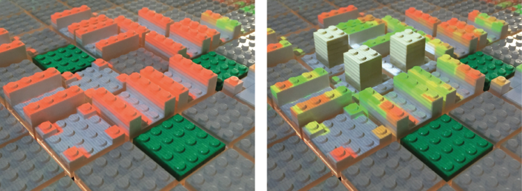
"Areas with poor walkability are colored red while areas with good walkability are colored green. An isolated residential area scores poorly (left). However, the same area augmented with a mix of non-residential use performs better (right)." Photo: Ira Winder
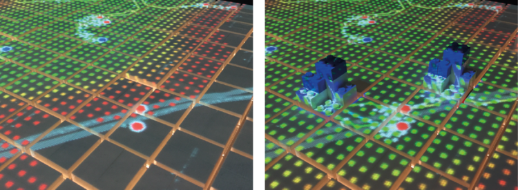
"A bus stop, represented by two red circles, is not within walking distance of nearby amenities (left). Amenities placed within walking distance of the bus stop increase simulated pedestrian activity and access to ammenities (right)." Photo: Ira Winder
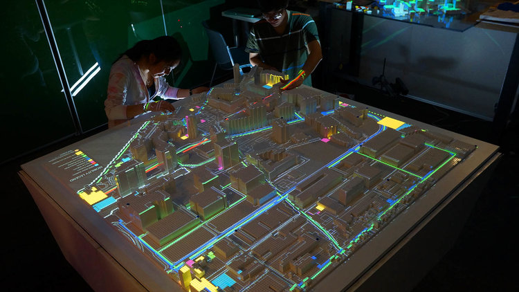
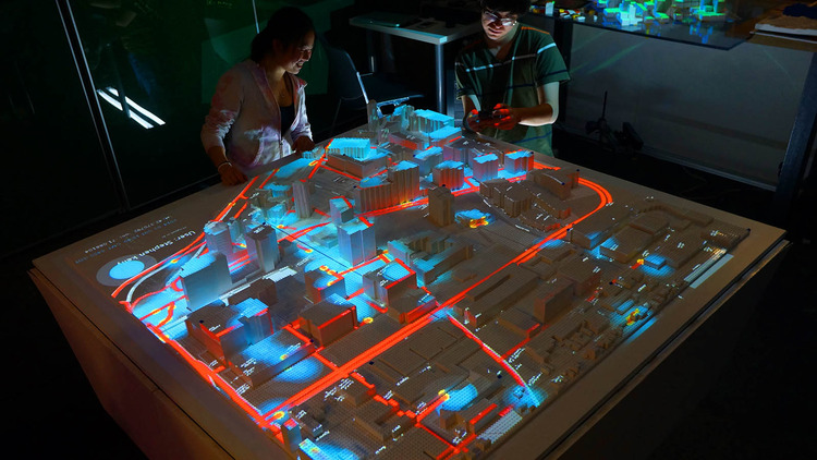
GIS data is used to create "LEGO-tized," 3-dimensional representations of existing urban areas. The model is augmented with layers of information via projection mapping. Layer: mobility system
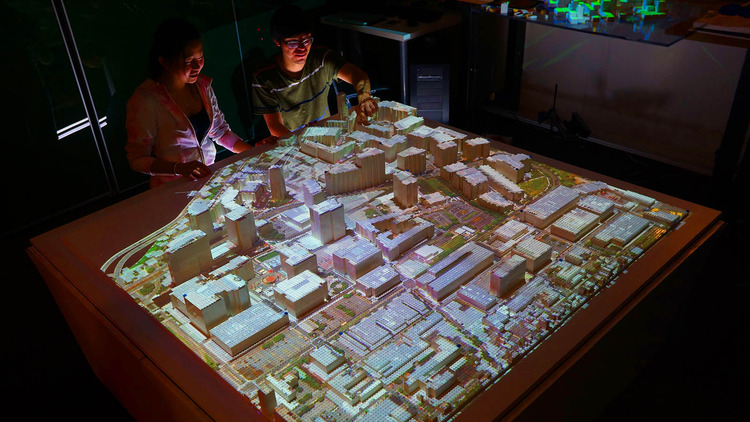
GIS data is used to create "LEGO-tized," 3-dimensional representations of existing urban areas. The model is augmented with layers of information via projection mapping. Layer: Google satellite image
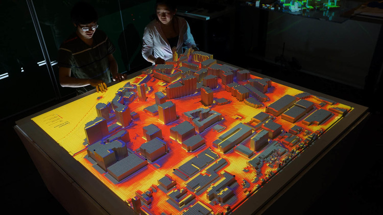
GIS data is used to create "LEGO-tized," 3-dimensional representations of existing urban areas. The model is augmented with layers of information via projection mapping. Layer: solar insolation
GIS data is used to create "LEGO-tized," 3-dimensional representations of existing urban areas. The model is augmented with layers of information via projection mapping. Layer: Twitter user activity
| In conclusion, the beauty and perhaps the most important feature of CityScope rests in its ease of understanding and simplicity of use, being a great example of a technology that adapts to the actions of people instead of the other way around. In other words, allowing urban issues to be more accessible for everyone and providing a much higher level of transparency and accountability than we are used to today. | En conclusión, la belleza y quizás la característica más importante de CityScope reside en la facilidad de entender su funcionamiento así como su simplicidad de uso, siendo un ejemplo perfecto de tecnología que se adapta a las acciones y necesidades de las personas, y no al revés. En otras palabras, permite que las cuestiones urbanas sean más accesibles para todo el mundo, proporcionando un nivel de transparencia (y de responsabilidad, por tanto, de los planificadores frente a la ciudadanía) mucho mayor al que, por el momento, estamos acostumbrados. |